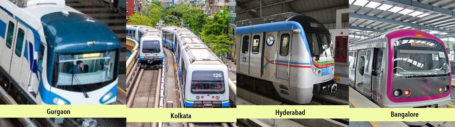
Bangalore Metro, or Namma Metro as it is called (meaning ‘our metro’) is the first metro system in South India and the second in India, to become operational after the Delhi Metro (excluding Kolkata, which became operational in the last century). Its first stretch of 6.7km was inaugurated in October 2011 after which another 18.8km was opened to the public, taking its cumulative operational length to 25.5km – this makes it the second-largest metro network in the country.
Bangalore Metro is gearing up to commission its first underground stretch of 4.8km – from MG Road to Magadi Road. If the tenders for the ‘sweets’ invited by BMRCL are any indication, the stretch might be inaugurated in April 2016 (Bangalore Metro Rail Corporation was planning to distribute 10,000 packets of laddoos at the inauguration of its much-delayed underground stretch of the east-west corridor, said media reports). Three more stretches (two overhead and one underground) are expected to be thrown open to public over the next twelve months – thus completing the phase-1.
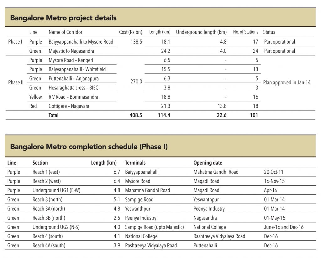
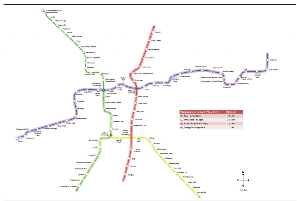
The Bangalore Metro master plan envisages two phases with a cumulative length of 114km. Phase 1 involves the construction of two corridors, which will together span 42.3km. This phase is expected to be completed by December 2016. Phase-2 involves extension of the four corridors built in phase-1 and the construction of two new lines. A total of 72.1km will be added at an investment of Rs 270bn by 2020.
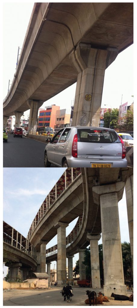
While the fact that it is about to complete its phase-1 in the next twelve months might appear to be a sign of robust execution by BMRCL, it is important to note that the foundation stone for this phase’s construction was laid by the then PM, Manmohan Singh, on 24 June 2006. Thereafter, it took the body five years to commission a stretch of 6.7km of overhead metro line, and yet another five years for a 4.8km underground line. Persistent delays due to heavy congestion on Bangalore roads and utility-shifting led to significant time and cost overruns.
There was also a proposal to build a 33km line from MG Road to Bangalore International Airport (BIA) for Rs 57.7bn – but this was scrapped keeping in mind its viability and cost. An airport metro extension from Nagavara to BIA might be considered for inclusion in phase-3, the DPR for which is being prepared.
After the success of the Delhi Metro, Chennai was one of the first cities to develop their metro masterplan, starting execution in the first phase in 2009. However, it took six years for the first leg of 10km to become operational. The project, plagued with the termination of multiple contracts (Gammon JV, Lanco, CCCL), and natural disasters (floods), has already exceeded its extended deadline. Even the remaining 35km of the phase 1, is not expected to be completed before December 2018.
Chennai Metro Rail will be the first metro project in the country that was conceived to integrate other public transportation systems. Integration with city/state bus and railways transport system was envisaged to provide seamless connectivity to passengers, along the lines of cities like Singapore, Hong Kong, and London. However, from the very start, the project met with multiple hurdles. As many as three accidents took place between 2012 and 2014, leading to the demise of three construction workers. In June 2015, an accident led to the death of a civilian along with injury to another.
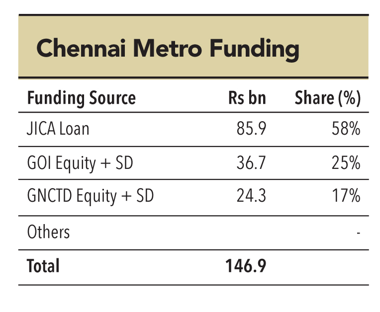
However, the biggest impediment that CMRL faced was the termination of three of its contracts. In July 2015, CMRL had to terminate the Rs 19.5bn contract with Gammon India-Mosmetrostroy JV for tunnelling operations over 18km and construction of 19 underground stations. The termination happened after Mosmetrostroy suddenly disappeared in May 2015, leaving the contract mid-way. Series of allegations and counter-allegations followed suit, and the matter is currently sub-judice. Similarly, CMRL had to terminate contracts awarded to Lanco (Rs 1.78bn, terminated in August 2013) and CCCL (Rs 2.24bn, terminated in January 2014) due to tardy progress. These incidents have led to cost and time over-runs, elevating the total project cost to Rs 190bn from the earlier envisaged Rs 147bn.
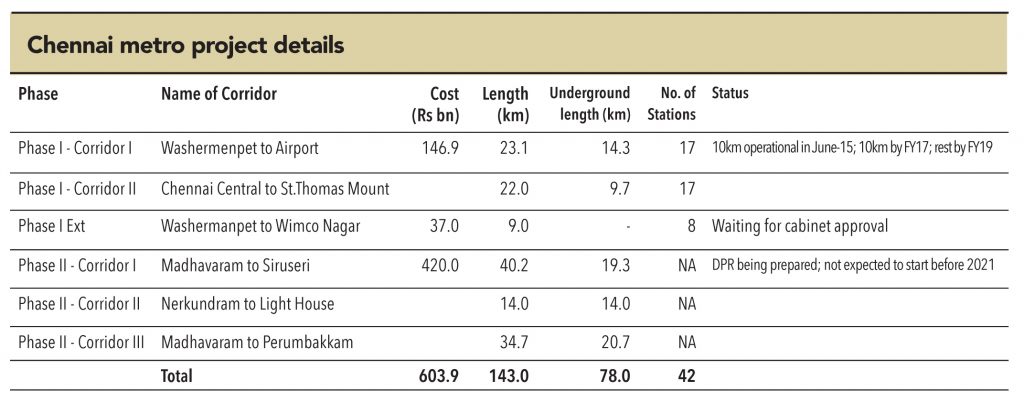
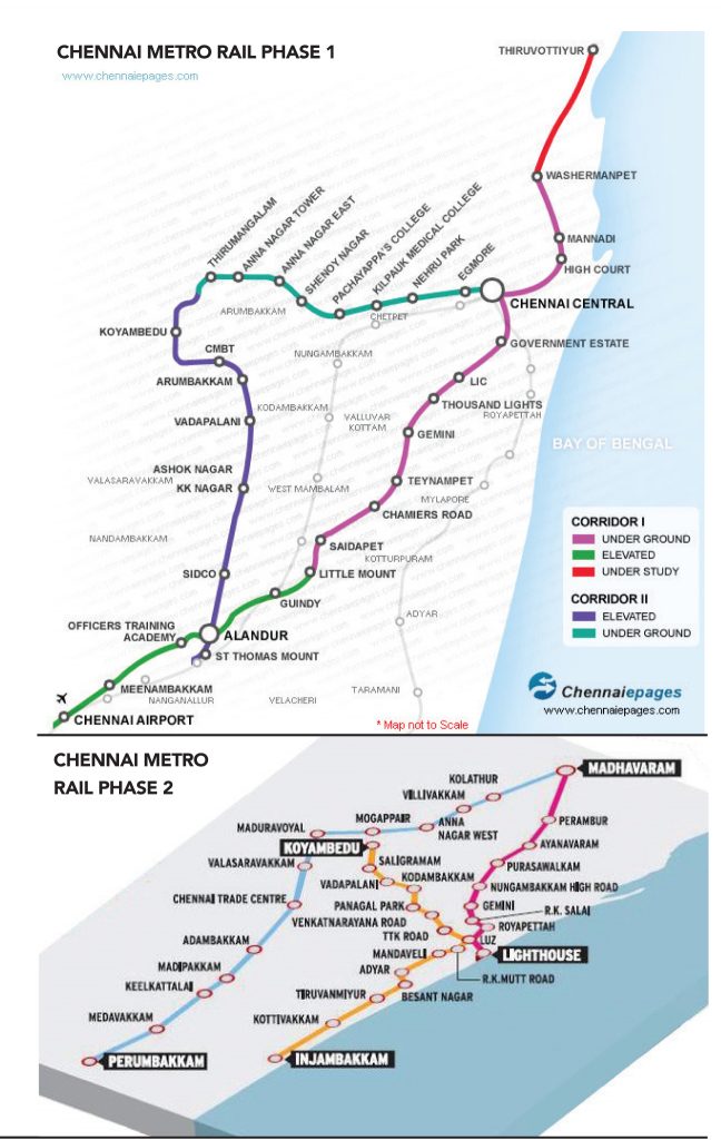
The masterplan for Chennai metro envisages two phases covering a total length of 143km and capex of Rs 600bn. While work on phase-1 started in 2009, the DPR for phase-2 is currently being prepared. The first stretch of phase-1, covering seven stations from Koyambedu to Alandur over a distance of 10km, began operation on 29 June 2015, with a woman driver of the Chennai Metro driving the first train out of Alandhur station. Another stretch of 10km is expected to start operations by March 2017, and the remaining by December 2018.
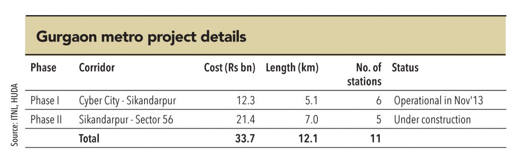
Gurgaon metro, or Rapid Metro as it is called, is one of the few privately-financed and operated metro networks.It was built by a consortium of ILFS and DLF, but DLF pulled out of the consortium later, making ILFS the sole owner. Currently, it has one operational line (phase-1), which spans 5.1km and covers six stations – connecting the Gurgaon Cyber City to the Delhi Metro Network at the Sikandarpur station. The line commenced operations in November 2013. The 99-year concession agreement with HUDA (Haryana Urban Development Authority) calls for ILFS sharing 5-10% of advertising revenues, along with Rs 7.65bn as ‘connectivity charges’ over the next 35 years. ILFS had financed the project with Rs 7.6bn of debt and the remaining as equity investment.
Phase-2, which extends 7km along Golf Course Road from Sikandarpur station at Bristol Chowk to Sector 56 in Gurgaon, is currently under construction.There is a proposal to extend the network towards Udyog Vihar in the north, which will increase the network’s length to almost 20km.
The Rapid Metro currently benefits from its connectivity to the Delhi metro network.Large numbers of commuters travel from Delhi to Gurgaon. Rapid Metro stands to benefit as the Delhi Metro expands its connectivity via phase-3 and phase-4. The Rapid metro SPV generated revenues of Rs 417.3mn in FY15, with loss of Rs 1.35bn.
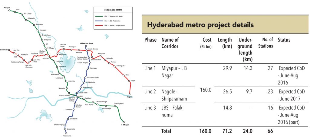
Hyderabad Metro has been, perhaps, one of the most talked about projects in the infrastructure space. Never before was a project of this magnitude and complexity awarded to a private player on a PPP basis (in India). While L&T, with all its technical expertise and financial might, could have been the only Indian company to be able to undertake such a project – the project has tested even the might of the Indian infrastructure Goliath. The project has been delayed by over a year now, with significant time and cost over-runs. Stage-1 is finally expected to begin operations on June 2, 2016 (Telangana Formation Day; Telangana being the new state to which the city now belongs).
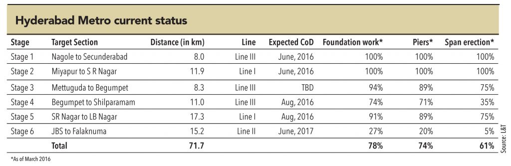
The current plan of the Hyderabad Metro is to develop 71.2km of metro network, covering 66 stations, to be serviced by three lines. The initial cost estimate of the project was Rs 141.3bn, but with one-year delay, it is likely to be closer to Rs 160bn. With the change in design scope and realignment, the final project cost may end up even higher than that.The construction of Hyderabad Metro is being carried out in six stages, across the three lines. Stage 1 and 2 are set to be commissioned in June-16, with almost 100% of the work complete by March16. Next stages are expected to be commissioned in a staggered manner over the next twelve months.
Hyderabad Metro is designed to have stations at an average interval of a kilometre – ensuring maximum convenience to passengers. The stations are designed to have adequate parking space and circulating areas, for multi-modal integration at the stations. When complete, it is expected to carry 1.7mn passenger daily in 2017 and 2.24mn by 2024. L&T expects the initial ridership revenue to constitute around 45% of the total revenues, with the rest coming from real-estate leases and advertising. Media report say that the company has tied up around 70% of the total real estate rentals in four metro stations. Despite this, it is not expected to report operational profits for at least the first five years of operations.
Kolkata is the main business, commercial, and financial hub of eastern and north-eastern India. It is also a major commercial and military port, and the only city in eastern India to have an international airport. Once India’s prime city, it now bears scarce resemblance to its glorious past.
Only 6.2% of the area of Kolkata is comprised of roads – compared to +20% for other metro cities in India. With a vehicle population estimated at about 1.6mn and 23.5mn transit trips a day in 2011, the city is bursting at its seams. With very little scope to increase the road area in the city, and a projected vehicle population of 3mn and 32mn transit trips in 2025, one can easily visualise the enormity of the problem.
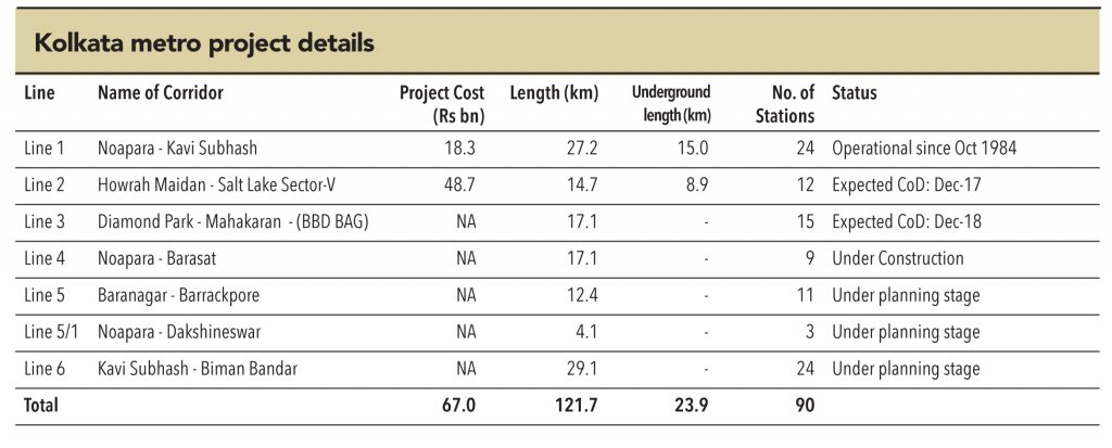
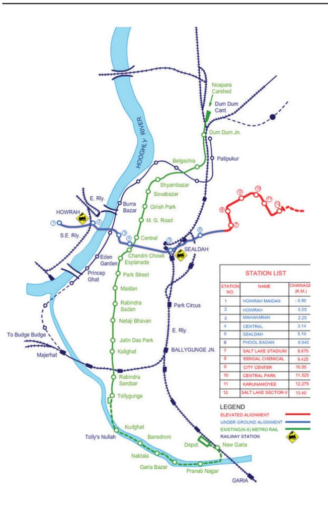
Nevertheless, Kolkata was the first city in India to have a metro network – currently operational 25.1km north-south line from Dum Dum to Kavi Subhash station, which began operations in 1984. This line, developed by Indian Railways, covers a total of 23 stations. Being the country’s first and completely indigenous process, the construction of the Kolkata Metro was more of a trial-and-error affair in contrast to the Delhi Metro, which had the involvement of numerous international consultants. As a result, it took nearly 23 years to construct 15 km of underground railway.
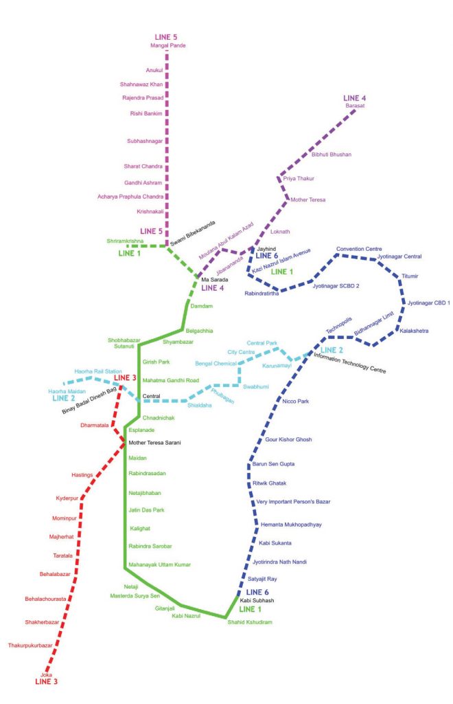
Currently, several extensions of Kolkata metro are under construction. Together, these are expected to add over 90km of network length. Among these, the upcoming the 14.7km East-West corridor (Line 2) will provide inter-modal connectivity with IR at Howrah and Sealdah stations, interchange with the existing metro network at the central station, as well as connections to ferry, buses, and trams. A new organisation, Kolkata Metro Rail Corporation Limited (KMRC), started the construction in 2009 – it was originally slated to be completed by 2012, but continuous delays led to the deadline being pushed back to June 2019. However, a stretch of 9km is being pushed to be commissioned by December 2017.
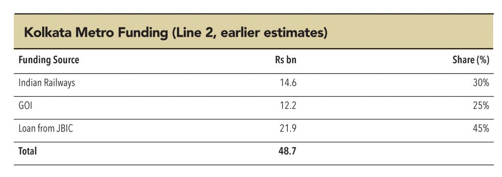
KMRCL, which was earlier a JV between the state and central government (similar to other metro projects across the country),is now governed by Indian Railways and the Urban Ministryafter the state government sought IR’s intervention. The challenges that the project faced, have also led to significant project cost escalation – from the earlier estimate of Rs 48.7bn to Rs 90bn.
Kolkata Metro Line 1 and 2
Kolkata Metro Masterplan
A metro map often represents the first impression of a city (maybe second, after the airport) to a traveller. If a map is cluttered and confusing, it makes traversing through the city that much more difficult. Conversely, a well designed and pleasant looking map makes travelling much more fun. More importantly, the design of a metro map can directly influence its ridership, and hence the congestion on city roads and the pollution levels too.
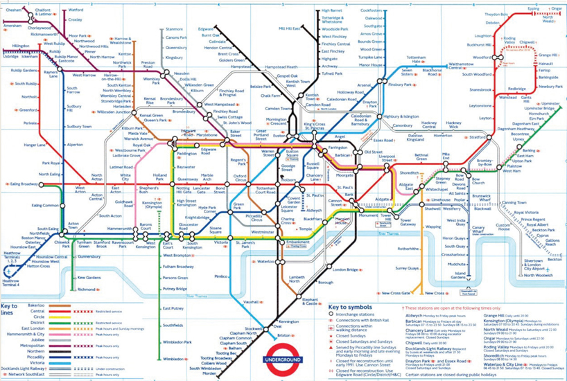
Over the years, designing the metro map has evolved into a confluence of art and science. Harry Beck mastered this art-cum-science with his design of the London Underground map in 1931. Keeping geographic accuracy aside, he laid out the map using beveled edges turning at clean 90-45-degree angles.London’s metro map has been the bar for metro maps across the world. It truly combines functionality with beauty, and serves as an inspiration to designers, even today.
Avoiding excess information: A metro map can actually be used to provide lot of information – but care needs to be taken to not ‘fill-up’ the map with excess information, which could make it cluttered and disorganised (e.g., the New York Subway Map) – even if that comes at the cost of setting the geographical accuracies aside (e.g., the London Tube Map).
Using contrast colours with 90-45 degree angles: These angles have been proven scientifically to be much more visually appealing to a viewer’s eyes. Also, mostly a light background with dark lines / annotations are used to provide soft and pleasant feeling to a map (with the exception of Montreal map, which uses a black background).
A look at some of the world’s best and worst designed metro maps:
London (opposite page): Elegant, beautiful and yet providing as much information as possible about the oldest and one of the largest metro networks in the world
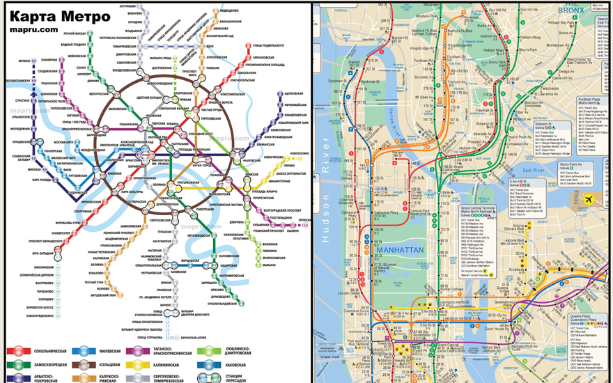
Moscow (top left) : The circular line pops out immediately,drawing your eyes to the centre of the city. The weights of the circles for each station are thicker than the lines, helping give more white space.
New York (Top right): Tries to convey too much information, especially the geographic locations of different stations. Also, not adhering to the 90-45-degree benchmark makes navigation extremely difficult. Desperately needs a makeover.
Chicago (Left) : Despite being a relatively smaller network, it’s a map that could have been designed better. Though it is simple to navigate and is surely not ugly, it doesn’t seem to be doing justice to the beautiful city of Chicago.


Subscribe to enjoy uninterrupted access


