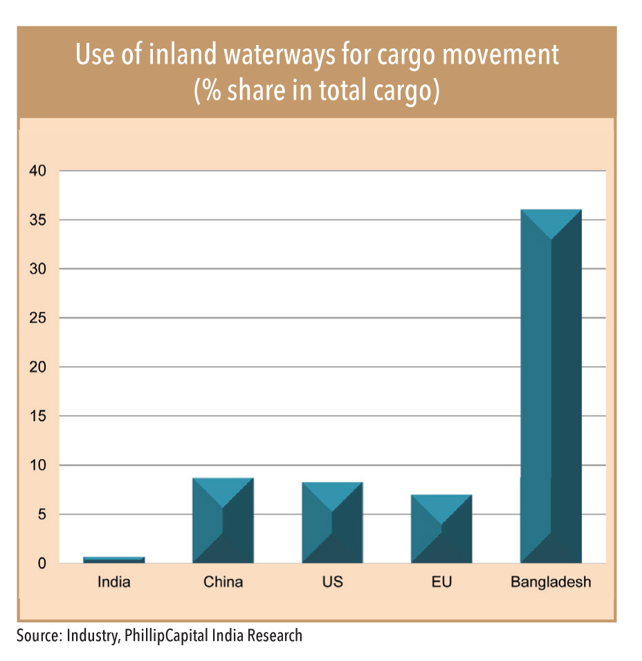
India has a network of inland waterways in the form of rivers, canals, backwaters and creeks, which is quite poorly developed. Though tAhe Ganga River was declared a national waterway (NW-1) in 1982, it took around 36 years for its first commercial container movement to take place – in November 2018 from Haldia to Varanasi over a distance of 1,600km. Globally, domestic waterways are found to be one of the most cost-effective and environmentally friendly means of transport. Only 5,200 km (36%) of major rivers and 485 km (3%) of canals of navigable inland waterways are used for cargo movement, underutilised compared with countries and regions like the United States, China, and the European Union. Only 0.6% of India’s cargo traffic is handled by inland water-transport, compared to China at 8.7%, the US at 8.3%, Bangladesh 36% and Europe at 7% (Source: KPMG).
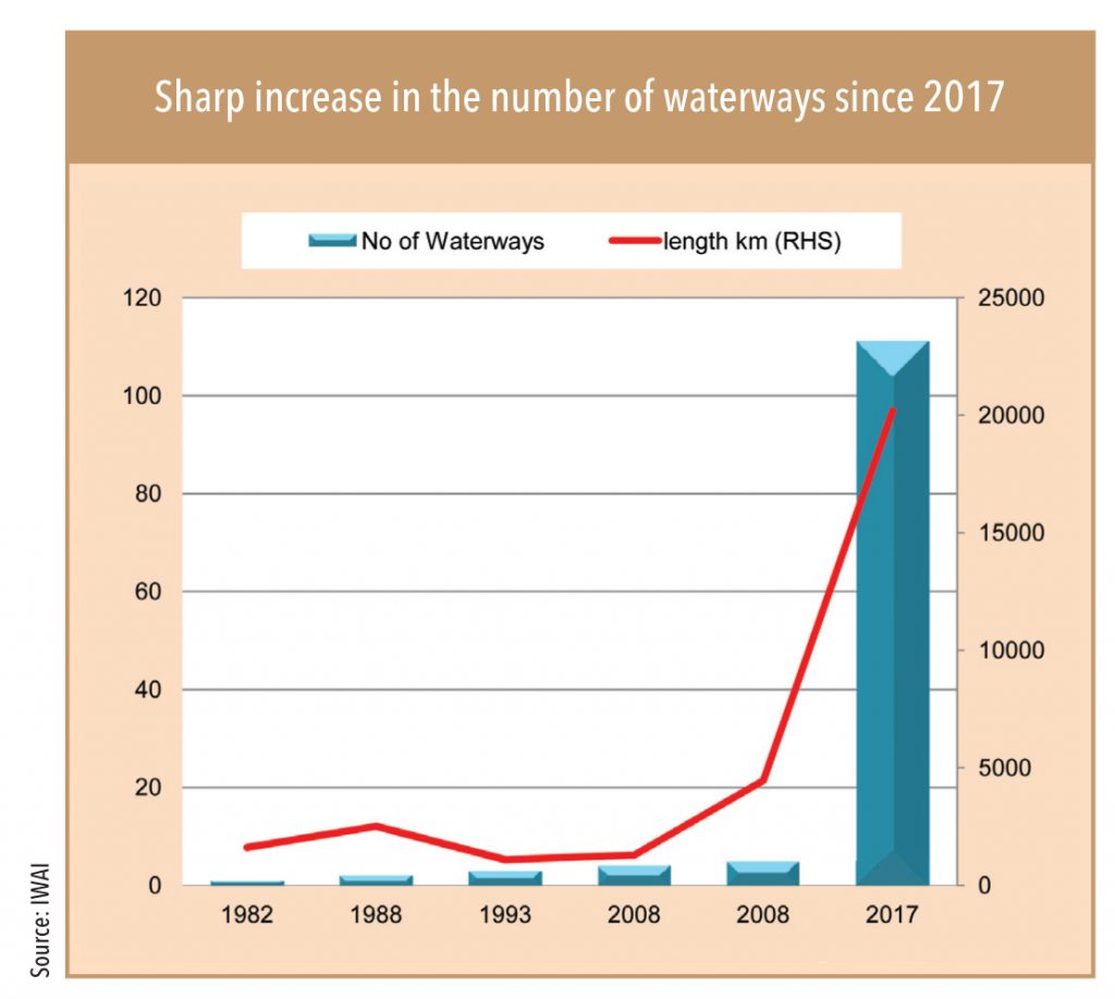
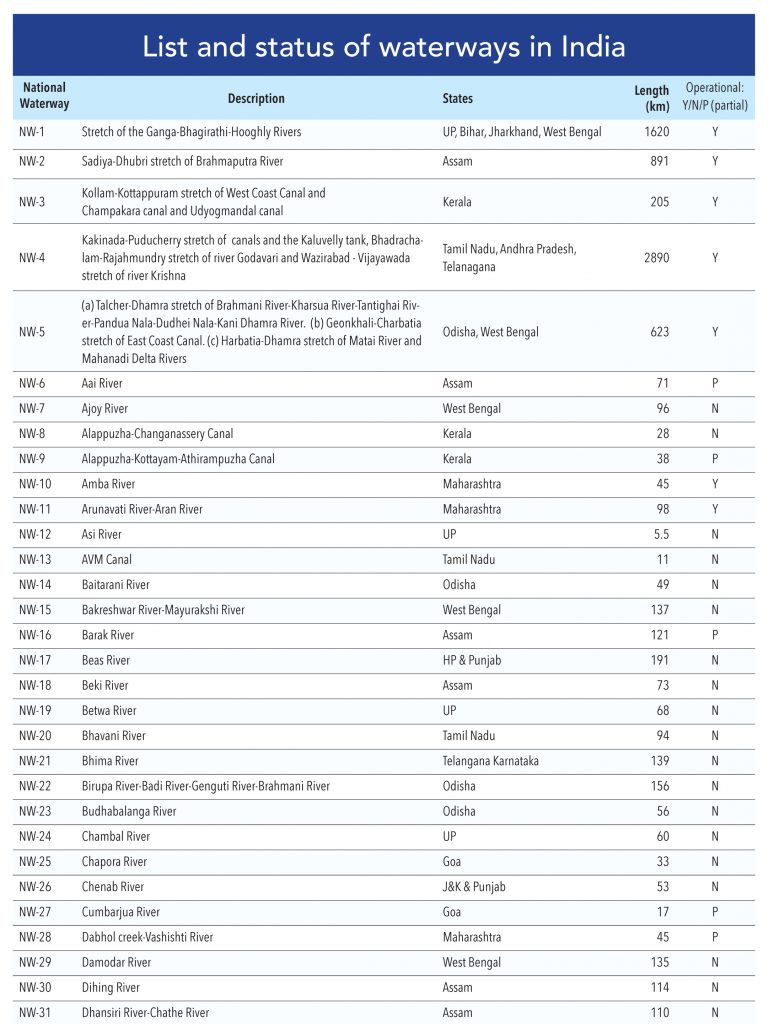
While navigation in rivers, lakes and other water bodies has been around since centuries, this has been more in the form of smaller vessels, connecting places not too far from each other. In some cases, especially near ports and coastal areas, it did evolve into more large-scale, commercial shipping. The Government has declared 111 National Waterways (NWs), which include five National Waterways, declared earlier, under the National Waterways Act, 2016. In fact, National Waterways -1 (NW-1) was declared a national waterway in 1982 well before formation of Inland Waterways Authority of India (IWT). NW-1 with a length of 1,620 km is the longest in India; the Ganga-Bhagirathi-Hoogly river system from Allahabad to Haldia. The 111 waterways pass through 24 states and two Union Territories (20,274 km) and involve 138 river systems, creeks, estuaries and canal systems, and also cut through around 20 wildlife protected areas.
IWAI’s development work provides business opportunities to players in the following fields:
• Cargo movement
• Dredging works
• Construction, operations, and maintenance of terminals
• Barge construction and operations
• Navigation aids
• Hydrographic surveys
• Manpower supply for vessels & terminals. Training of vessel crews
• Stevedoring and forwarding
• Cruise operations
• Consultancy services for techno-economic feasibility, environmental & social impact and market analysis studies, and preparation of DPRs.
• Project management consultancy.
• Construction supervision.
• Proof checking of design.
• Model studies.
Number of national waterways under IWAI
There is significant potential for waterways for containers and bulk cargo. The scope of work for inland waterways has increased significantly after 106 waterways were declared in 2016. Development work is on-going on eight waterways while around 42 are being studied (primary) for potential cargo movement. The government commitment to increase the share of waterways and strong follow up by the inland waterways authority is expected to bring success for inland waterways over the long term.
• The waterways are complex to develop compared to coastal shipping and require huge data collection to understand the behaviour of river in different seasons, sped of water flows and soil accumulation.
• IWAI has started the development work on 8 new National Waterways in FY18.
• Strong preparatory work for NW 1 to 5 and active initiative by IWAI to develop new waterways has started to show results.
• Out of the total 111 waterways, NW-1, 2, and 3 are already operational and are used for cargo and passenger vessels. Companies such as Pepsico, Emami Agrotech, IFFCO fertilizer and Dabur India have moved their cargo on NW-1. These three waterways are partially developed with fairways, navigational aids, jetties, and terminals. They also have mechanized equipment handling facilities for loading and unloading cargo.
• Two barges carrying fly ash sailed from Kahalgaon (Bihar) for Pandu island (Assam) –one of the longest hauls in India’s inland waterways, covering 2,085 km. Crossing three waterways – NW-1, 2, and the Indo-Bangladesh Protocol Route – this journey signalled the beginning of integrated movement through multiple waterways.
• IWAI has signed an agreement with Cochin Shipyard Limited for construction and supply of 10 Ro-Ro/Ro-Pax vessels at a cost of Rs 1.1bn in July 2018. The vessels will be delivered between June to December, 2019 for deployment on NW-1, 2, and 3.
• A detailed project report for development of NW-4 and 5 was completed in 2010 and these waterways are being developed for commercial navigation.
• For the newly declared 106 waterways, techno-economic feasibility studies have been initiated. Detailed project report for development of Kosi (NW-58), Gandak (NW-37), Ghaghra (NW-40), Mandovi (NW -68), Zuari (NW -111), and Cumberjua (NW-27) have been prepared.
• Jal Marg Vikas Project (JMVP) started in 2014 on NW-1 for commercial navigation on the Varanasi-Haldia stretch of the Ganga River. It has seen completion of c.Rs 20bn of work, out of a planned capital expenditure of Rs 53.7bn (with technical and financial assistance of World Bank).
Connecting cargo owners and shippers
The IWAI launched a dedicated portal to connect cargo owners and shippers with real time data on availability of vessels. The landmark e-connect measure will enable direct interaction among the vessel operators, shippers and cargo owners as currently, there is no platform for information on the availability of vessels in the market. It has been designed and developed by the in-house IT Department and the Traffic Wing of IWAI as part of its preparedness for optimal use of its on-going capacity development on various National Waterways. Named as the Forum of Cargo-Owners and Logistics-Operators (FOCAL), the link of the portal is available on the homepage of IWAI website www.iwai.nic.in.
Current statistics
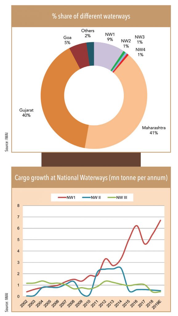
• Maharashtra and Gujarat constitute a large chunk of the total cargo carried through inland waterways in India. Out of the total 71 mtpa, 39% is through Maharashtra waterways (NW-10; NW-83 and NW -85) and 36% is through Gujarat (NW-73 and NW -100).
• The share of NW-1, 2, and 3 is around 10%, mainly from NW-1.
• Share of Goa waterways (NW-68 and NW -111) has come down substantially – to an annual volume of 3.6mn tonne in FY19 from 55mn tonne in FY11.
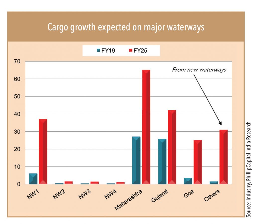
Demand to increase to c.200mn tonne by 2025; major on NW-1
As per an industry study, demand for cargo on national waterways is expected to increase to c.200mn tonne by 2025 from 71mtpa currently. Major growth is seen on NW-1 with cargo volume of c.37mn tonne per annum by 2025 (current 6.5mn). Major growth is likely from a shift from roads to rails, generating additional c.21mn tonne annual cargo movement on NW-1. Construction material is expected to contribute around 48% of total cargo on NW-1 and coal 22%; minerals and foods are estimated to contribute 6% each. Around 30mn tonne is expected to be generated on newly developed waterways
• IWT provides a supplementary mode of transport, which is cost effective, fuel efficient and environment friendly.
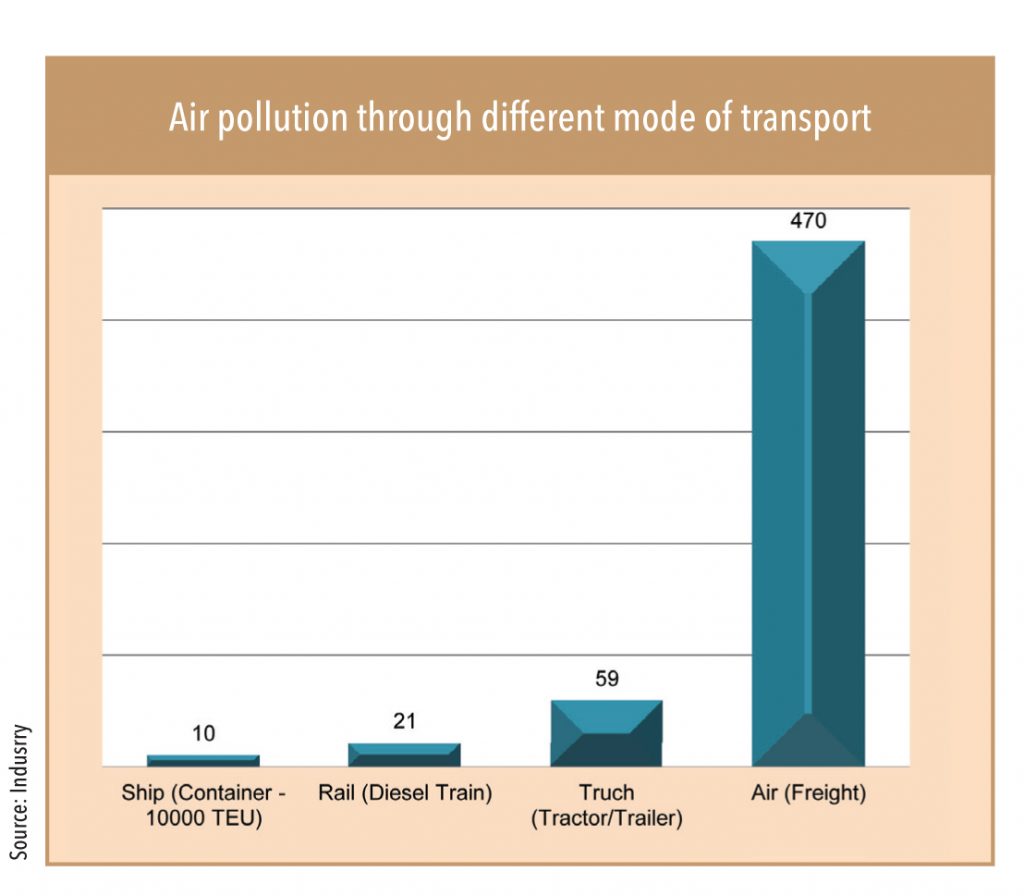
• Low emissions; CO2 emission is 50% of trucks: CO2 equivalent
greenhouse gases emission per tonne-km of cargo transportation is 15g by IWT, 28g by rail, and 64g by road transport
• Negligible land requirement
• Safe mode for hazardous and over-dimensional cargo • Low energy consumption: 1 HP can carry 4000 kg load in water, 500 kg by rail, and 150 kg on road.
• Low fuel cost: 1-litre fuel can move 105 tonne-km by IWT, 85 tonne-km by rail, and 24 tonne-km of freight by road.
• Cost of developing waterways much lower than rail and road
• IWT can provide an optimal modal mix by integrating river transport with other modes, thereby reducing total logistics cost.
• It eases congestion on road and rail networks.
• IWT requires very little land acquisition as compared to road and rail modes. Caters to the needs of the relatively under-developed hinterland.
• Low energy consumption: 1 HP can carry 4000 kg load in water, 500 kg by rail, and 150 kg on road.
• Low fuel cost: 1-litre fuel can move 105 tonne-km by IWT, 85 tonne-km by rail, and 24 tonne-km of freight by road.
• Cost of developing waterways much lower than rail and road
• IWT can provide an optimal modal mix by integrating river transport with other modes, thereby reducing total logistics cost.
• It eases congestion on road and rail networks.
• IWT requires very little land acquisition as compared to road and rail modes. Caters to the needs of the relatively under-developed hinterland.
Jal Marg Vikas is a unique project where government, public, and private sectors joined hands to provide an alternative mode of transport on national waterways -1. The government is developing NW-1 (River Ganga) under the Jal Marg Vikas Project (JMVP) – from Haldia to Varanasi with technical and financial assistance from the World Bank at an estimated cost of Rs 54bn. Inland Waterways Authority of India (IWAI) is the project Implementing Agency. The project envisages various sub-projects such as fairway development, navigational aids, construction of multi-modal terminals at Varanasi, Sahibganj, and Haldia, construction of new navigational lock at Farakka, bank protection work, movement of LNG vessels, LNG bunkering facilities etc.
Under the project
o 3 multimodal terminals (Varanasi, Sahebganj, and Haldia)
o 2 intermodal terminals
o 5 roll on-roll off (ro-ro) terminal pairs
o A new navigation lock at Farakka
o Assured depth dredging
o Integrated vessel repair and maintenance facility
o Differential Global Positioning System (DGPS)
o River Information System (RIS)
o River training
o River conservancy works
o Repair & Maintenance facilities; slipways; dry-docking and fuelling facilities
o Night navigation facilities for 24×7 navigation
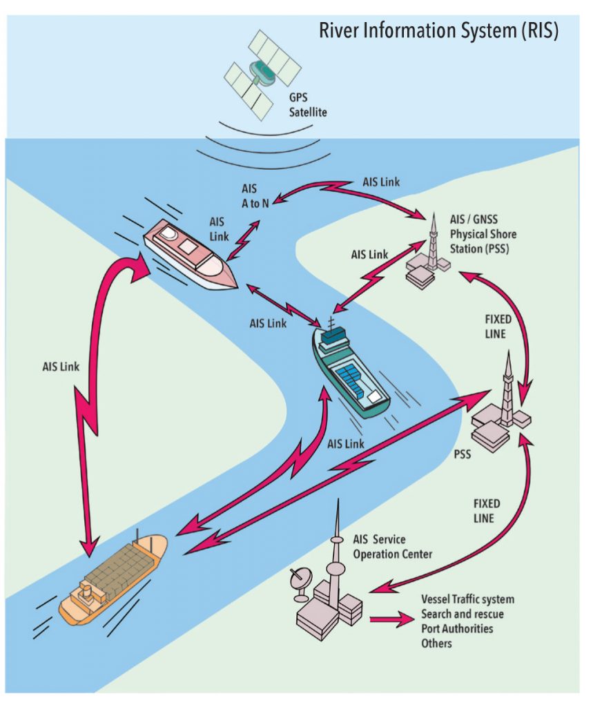
River Information Services (RIS – Phase 1)
RIS has the goal of safe and efficient transport by avoiding the following risk:
• Ship-to-ship collisons
• Ship – Bridge collisions
• Groundings
• Impoved efficiency
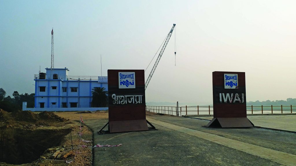
The Varanasi Multimodal Terminal and Freight village
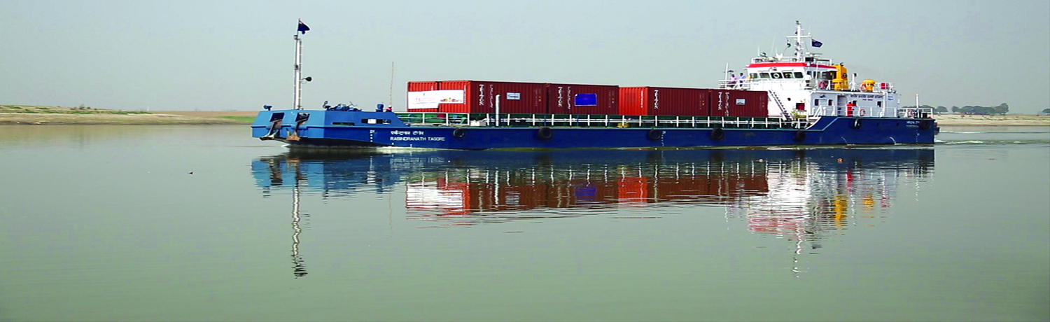
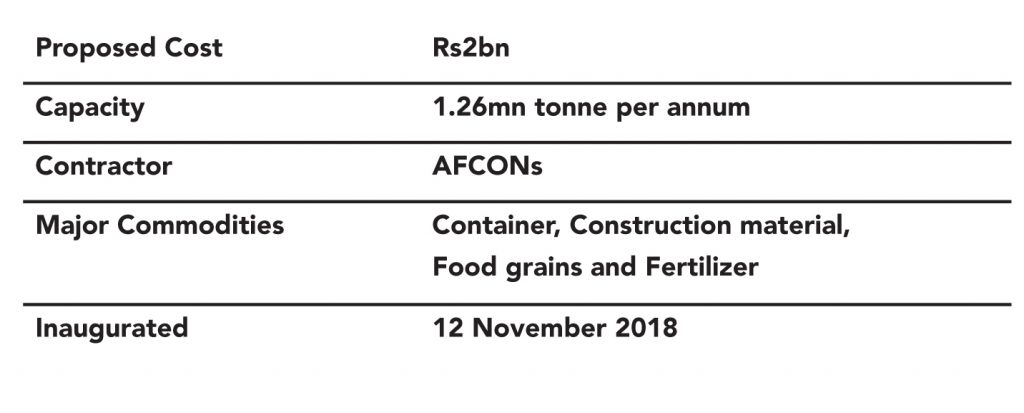
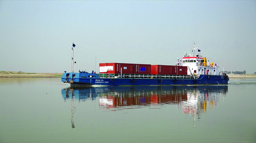
This was inaugurated by Prime Minister Narendra Modi on 12 November 2018 on the day it received its first container cargo. The MMT has a capacity of 1.26mn tonnes per annum of cargo and is built on an area of 34 hectares. Varanasi is the first of the three multi-modal terminals and two inter-modal terminals being constructed on the Ganga River. IWAI transported its first container cargo belonging to PepsiCo (India) from Kolkata to Varanasi on NW-1 on 30 October 2018 – the 1,500-dwt vessel, named MV Rabindranath Tagore, carried 16 containers of 9 tonne weight and took 12 days to sail. This was the first container movement on an inland waterway in India after Independence. After development of night navigation facilities on the entire stretch, travel time form Varanasi to Haldia can come down to 4-5 days from current 12-14 days, a significant advantage for cargo movement on the NW-1.
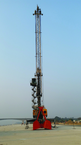
The terminal has imported two cranes for bulk and container handling at a cost of c.Rs 4.9bn. Since the approach road is not yet developed and cargo movement frequency is very low, the driver (crane operator) is called from Kolkata when required. “It (the terminal) will have a permanent driver once it will start regular service,” said a local employee.
NW-1
• NW-1 is being developed for navigation of large vessels of up to 3,000 tonnes of weight by maintaining a draft of 2-3 metres.
• Multi-Modal Terminal and Freight Village at Varanasi are likely to generate direct employment for 500 people and create more than 2,000 indirect employment opportunities.
• The objective is to promote inland waterways as a cheaper and more environment friendly means of transport, especially for cargo movement.
• The inland waterways terminal at Varanasi has a natural draft of 15mtr and both sides have sharp turn, which restricts sand accumulation – so maintenance-dredging cost is very low for terminal.
• The cost of developing the first phase is Rs 1.70bn with an additional cost of Rs 200mn for constructing the connecting road.
• Varanasi freight village will be developed on 100 acre land with cargo projection of 3.21mn tonne including aggregation and transhipment. Project cost is Rs 5bn (50% from private players).
• DIB approval received while Cabinet approval is pending.
• “Ganaga River is very dynamic with around 5-6mn tonne annual slit generation and carry around 250m3 silt annually with its flow and depending on size and speed of water, siltation keeps changing,” said at technical member at government agency. “Initially we though auction of river sand can reduce the dredging cost for the inland waterways while during interaction with officers we come to know that river sand is not very useful as it is too fine and it is the property of the state government under the state mineral policy”, he added.
• Total dredging cost for NW-1 is estimated at Rs 22bn and dredging is divided in three sections: (1) Haldia to Farakka given to Dredging Corporation of India (DCI); (2) Farakka to Barh given to Adani, and (3) Barh to Varanshi is in the tender stage.
RIS and VTSM systems on the Ganga River
IWAI has installed the River Information System (RIS) and Vessel Traffic Management System (VTMS) on the Farakka to Patna stretch of the Ganga River. As a part of the project, six base stations and one control station have been installed in Bihar. The route will be navigable for the entire year (against only for six months currently. The project has depth of 3mtr for navigation, which will increase the cargo handling capacity of vessels to 1,200-3,000 dead weight tonnage (DWT). The development is also attracting one the biggest-ever dredging investment for maintaining least available depth of three metres all along the route round the year.
With the night navigation facility from Haldia to Varanasi (once complete), the travel time for vessels will come down to 4-5 days from current 12-14 days
Major cargo demand
There are around 11 major power plants located on the banks of NW1 with a cumulative capacity of 12,000 MW. Total coal requirement for the proposed power plants located on NW-1 is about 52mtpa, which can translate into a demand of c.10mtpa, assuming 20% imported coal is transported through NW-1. NTPC has already started a project for transportation of 21mt of imported coal over seven years from Haldia to Farakka for NTPC on NW-1. Apart from coal, major cargo on NW-1 is expected is containers, cement, fertilizer, fly ash, hot rolled steel, coils, tyres, machinery, jute, spare parts, stone, chips, HSD oil, soybean extracts, lube, oil, sand, manganese ore, coke.
Standardization in ship design for the Ganga River
• In August 2018, IWAI made public 13 standardised state-of-the-art ship designs suitable for large barge haulage on river Ganga (National Waterway-1).
• For the shipbuilding industry, the new designs will translate into a savings of Rs 3-5mn in the building of a vessel.
• Available free on the IWAI website, the designs remove ambiguity on the class and type of vessels that can sail on river Ganga with efficient manoeuvrability.
• These vessels will sail even in depths of about two metres carrying about 350 cars on a five-deck car carrier. Some of the designs would enable movement of bulk cargo carriers with capacity of 2500 tonnes at three metres depth, thereby, removing almost 150 truckloads of pressure from the road or one full rail rake with the plying of just one such vessel.
• The new designs for various categories of dry and liquid bulk carrier, Ro-Ro vessels, car carrier, container carrier, LNG carrier, Tug Barge flotilla have been made by DST, a German company that specialises in low-draft and high-carrying-capacity vessels. The model testing of the designs was done at Duisburg, Germany.
• IWAI has had 15 successful pilot movements on various stretches of NWs.
• In July 2018, it launched a dedicated portal ‘FOCAL’ to connect cargo owners and shippers with real-time data on availability of vessels.
• River transport increases the length of travel in most cases due to bends and diversions. Road distance between Allahabad and Haldia is 900 km but it is 1,600 km by waterways. For Deendayal Port (i.e Kandla) to Paradip Port, the rail route is approximately 2,000 km but the sea route will include a journey around Sri Lanka, with a total length of approximately 4,000 km.
• Road transport has higher travel speed (c.20km per hour) compared with coastal shipping (c.7km per hour) taking in account all delays and average night halts.
• Tantighai / Kani River on NW-5 has 24 bends on 45 km length and the radius of curvature in these bends varies from 190mtr to 620mtr; against this requirement for Class-4 Waterways is 700mtr, which makes navigation difficult and increase the cost of dredging).
• “River navigation depends on water levels, which vary during seasons and there is no formal arrangement for the use of water for cargo movement,” said the senior officer in a government agency. The discharge available in the river Brahmani from Talcher to Jokadia works out to 55 cumecs (cubic meters per second) during the lean season while c.110 cumecs is required to ensure a navigable depth of 2m in a channel of 45m bed width. IWAI has proposed five barrages from Talcher to Jakodia to ensure 2m depth of water.
• River development takes a lot of time compared to coastal development. Setting up night navigation and river information systems is costly. The dynamic nature of rivers need detailed study and a longer history. The changes in water levels and speed of water have huge variation on season as well as on a daily basis. The speed of water in the Ganga River doubles from c.3 meters per second to c.7 meters per second in a very short span.
• Soil accumulation changes, with speed and flow of water, create challenges for dredging and navigation on waterways. “Soil accumulation keeps changing with seasons and due to the difference in water flow. We are studying specific locations to reduce the cost of dredging; many locations don’t need dredging,” said an officer at the IWAI. Dredging is one of the major costs for the inland waterways. IWAI has moved to a model of maintenance of guaranteed (assured) minimum depth for a period of five years, which is estimated to lead to cost savings of c.Rs 5.5-7.0bn annually for India, compared to quantity-based dredging. Outsourcing of dredging from private players is likely to increase the output to 0.4mn m3 per year compared to in-house dredgers’ capacity of 0.18mn m3. NW-1 is divided into three stages for dredging and work has been awarded to Adani for assured depth (3 metres) dredging between Farakka to Kahalgaon.
• Tough absolute cost of coastal movement from port to port is quite less compared to road and rail movement, it is not so simple and one to one equation. Road transport is able to give point-to-point solutions. On the other hand, coastal and railway movements needs road transport for providing last-mile delivery, which makes it complex and costly – involving multiple modes and handling. Coastal waterways also have longer transit times and could prove less reliable than trucks (due to weather and port delays) making them inappropriate for time-sensitive transportation. For west coast to east coast journeys, ships need to circumnavigate Sri Lanka, increasing the transit time by around two days.
• Economic viability of a waterway to carry traffic as an alternative to rail and road depends on its length which should be a minimum 500 km and 250 km for both cases respectively. It should have a large hinterland coverage area and potential in order to generate enough traffic on routes.
Cargo connectivity to the northeast is expected to improve significantly with the use of inland waterways. Cargo movement through NW-2 in the northeast is already operational and is being developed for improving terminal infrastructure. The development of waterways is playing big role in connectivity to northeast India mainly through:
(1) Indo Bangladesh protocol
(2) Kaladan multi modal project.
What is it?
• The Protocol is an agreement between India and Bangladesh. It was first signed in 1972 and is valid up to 5th June 2020. It is a mutually beneficial arrangement for using waterways for commercial purposes. The two sides agreed to consider inclusion of Rupnarayanriver (National Waterway-86) from Geonkhali to Kolaghat in the protocol route recently and to declare Kolaghatin West Bengal as new Port of Call. India has proposed for an extension of the protocol routes from Kolkata up to Silchar in Assam. Day to day protocol permissions are issued by IWAI to barges to sail in the designated port of calls in India and Bangladesh.
What will it do?
• The new arrangement will facilitate movement of flyash, cement, construction materials, etc., from India to Bangladesh through IWT on Rupnarayanriver.
• Currently 3.5 MMT cargo is transported on protocol routes through inland waterways, which is expected to increase substantially after the declaration of additional Ports of Call and extension of protocol routes.
• The North Eastern states would be connected directly to the ports of Kolkata and Haldia in India and Mongla in Bangladesh through waterways, which would facilitate movement EXIM cargo and reduce logistics costs.
Indo Bangladesh Protocol on IWT
• This is an inland water transit and trade protocol between India and Bangladesh.
• Under this, inland vessels of one country can transit through specific routes of the other.
• Existing protocol routes: Kolkatta – Silghat – Kolkatta, Kolkatta – Karimganj – Kolkatta, Rajshahi – Dhulian – Rajshaji, Silghat – Karimganji – Silghat.
• The protocol also allows trade through IWT.
• Five ports of call have been designated in each country. These are – Haldia, Kolkatta, Pandu, Karimganj and Silghat in India and Narayanganj, Khulna, Mongla Sirajganj and Ashuganj in Bangladesh.
• More than 1.5mn tonne of fly ash is transported between Kolkatta / Haldia and Bangladesh every year under this protocol.
• Recently, 90 consignments of project material for ONGC’s Palatana Power Plant (being constructed near Agartala in Tripura) moved through inland waterways under the Indo Bangladesh Protocol.
KALADAN MULTI-MODAL TRANSIT TRANSPORT PROJECT
What is it?
• It will connect the eastern Indian seaport of Kolkata with Sittwe seaport in Rakhine State, Myanmar by sea. In Myanmar, it will then link Sittwe seaport to Paletwa in Chin State via the Kaladan riverboat route, and then from Paletwa by road to Mizoram state in Northeast India.
• Under this, the Ministry of external affairs (MEA) will provide alternate connectivity from Mizoram to Kolkata ports through river Kaladan in Myanmar coast and IWT from Sittwe to Paletwa in Myanmar and thereafter by road to Mizoram.
• It is a US$ 484mn project.
• Originally, the project was scheduled to be completed by 2014, but is now expected to be operational only by 2019-20. All components of the project, including Sittwe port and power, river dredging, Paletwa jetty, are complete, except the under construction Zorinpui-Paletwaa road whose construction commenced in April 2018.
Indigo Seaways Pvt. Ltd SPV
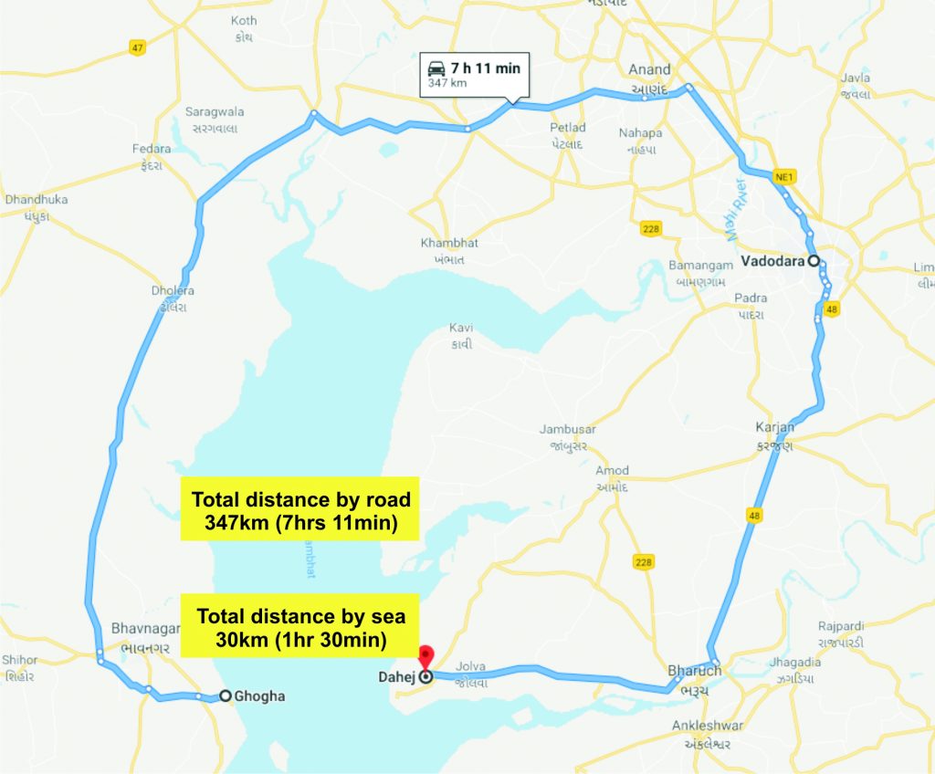
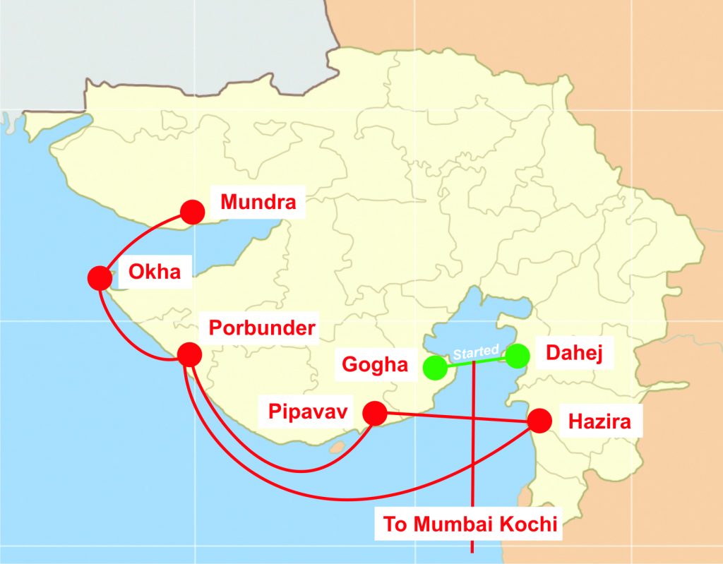
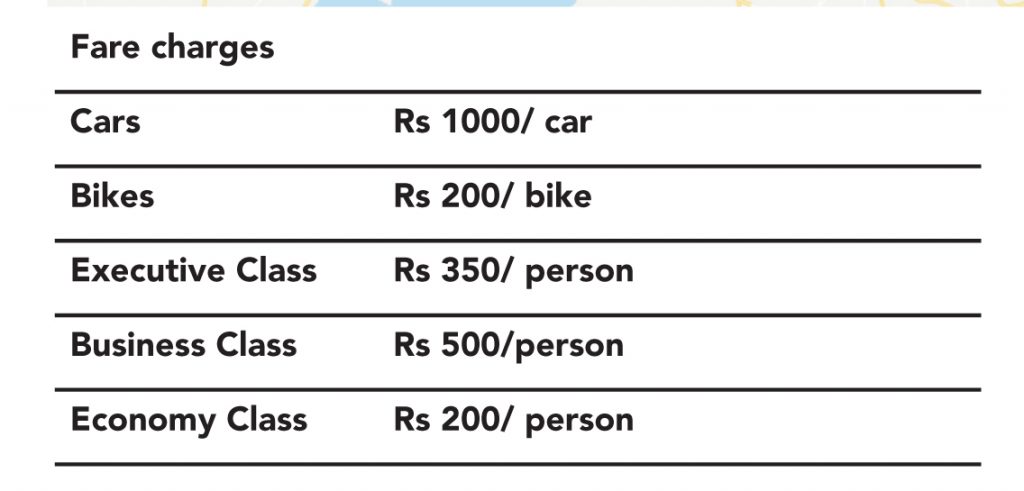
It is floated by Detox group in Surat for India’s first roll on-roll off services in the Gulf of Cambay on the Public Private Partnership (PPP) model. Indigo Seaway Pvt Ltd. and Gujarat Maritime Board (GMB) had entered into an agreement to run the Roll On-Roll Off (Ro-Ro) ferry service. The ferry service started in October 2018.
• This ferry service project cost stands at Rs 6.14bn.
• For this project, the central government has allocated Rs 1.17bn for dredging work at both Ghogha and Dahej under the Sagarmala initiative.
• The service has reduced the travel time between Ghogha in Saurashtra and Dahej in South Gujarat from about seven or eight hours to just over an hour. The distance between the two places is reduced to just 31km from the current distance of 360km.
• Ship is 2015 built in Korea with 110mtr length and operates with draft of 3.8mtr and speed of 16-18 knots per hr.
• It is currently doing four trips daily, two from Dahej and two from Ghogha with around 115-130 vehicles and 450-500 passengers per trip. The ferry vessel with carrying capacity of 500 passengers and 100-150 vehicles needs maximum draft of 4.50 m while service speed is ~20 knots (40 km/hour). Total sailing time is around 60 minutes, excluding birthing and unberthing time. The estimated demand between two terminals is estimated ~ 600 vehicles per day, and vehicle carrying capacity is 100 vehicles, the vessel can have 6 departures per day from one side. GMB has decided to opt for 150 vehicles per trip and four departures per day.
Goa Waterways
Waterways in Goa have been declared as National Waterways (NWs) under the National Waterways Act, 2016. Development of these waterways is undertaken through various measures including dredging based on the recommendations in feasibility/ Detailed Project Reports (DPRs). These reports for NWs on Mandovi and Zuari rivers have been completed. In order to minimize the adverse impact of developmental works on the marine ecology, if any, the recommendations of detailed Environment Impact Assessment (EIA)/ Environment Management Plan (EMP)/ Coastal Regulation Zone (CRZ) and Wild Life Clearance studies commissioned for NW-68 and NW-111 would be taken into account.
List of Goa waterways
India Nepal trade through NW-1
• India is actively pursuing development of inland waterways from Kolkata to Indian states of Uttar Pradesh and Bihar. Nepal will use the Indian facilities to import and export cargos via its two rivers — Koshi and Gandak — to reach Haldia port in Kolkata. Officials from both countries have held meetings to review and revisit the bilateral transit and trade treaties.
• During the meeting in New Delhi, the Nepali side had proposed using two Indian transit points for inland water navigation: Sahibgunj (Jharkhand) and Kalughat (Bihar) via Haldia port up to Nepali border and then use the Koshi and Narayani (called Gandak in India) rivers respectively to reach the Nepali destination.


Subscribe to enjoy uninterrupted access


